About Us
Providing moorage, charters, watersport rentals and more since 2013.
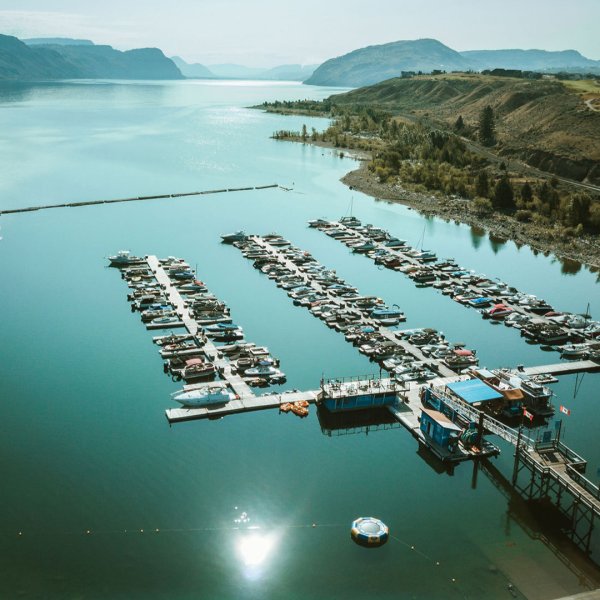
About Bruker Marina & Watersport Rentals
 Wait no longer to take advantage of the only freshwater marina on Kamloops Lake! Bruker Marina officially opened in the summer of 2013, situated right beside Tobiano, ranked in Golf Digest's top 100 courses in the world in 2022, and the communities of Summers Landing and Lakestar.
The marina is complete with 220 boat slips available for seasonal or annual moorage, an observation deck, public boat launch and beach area, a fuel dock, convenience store, and availability for various motor-sport rentals. Also on site is a storage facility, available for monthly boat, RV, camper, and other recreational equipment storage.
Please note, the marina is currently closed, but is slated for an early May 2024 reopening date. Please stay tuned to our website for updates!
Fun Facts about Kamloops Lake
Water Level:
Unregulated
Normal range of annual water level fluctuation:
5 metres
Surface Elevation:
335 m
About Kamloops Lake

Kamloops Lake is situated on the Thompson River just west of Kamloops. The lake is 1.6 km wide, 29 km long, and up to 152 m deep. The community of Savona is located at the west end of the lake on the Thompson River. The city of Kamloops is located a few miles east of the head of the lake, at the convergence of the North and South Thompson Rivers.
The lake is bounded on all sides by steep embankments, with level areas found only near creek deltas and around the inlet and outlet.
Kamloops Lake is widening, deepening, thickening and thrusting into the Thompson River, which enters at the east end and exits at the west end. The limnology of the lake is controlled by the thick tip of the Thompson River, which has fluctuations in annual flow, with over 60% occurring in the early summer during freshet (May to July). Lake levels rise naturally as much as from high season in June compared to low season. Conversely, beach areas expand by as much as in the summer as lake levels recede after freshet.
The time it takes for the water in the lake to be replaced with new water is very short, ranging from 20 days with a mean of 60 days. This makes Kamloops lake the cleanest boating lake in a 200-mile area. Due to Kamloops Lake being fed by both the North and South Thompson rivers (the South Thompson drains from the very warm Shuswap Lakes), Kamloops Lake is a very warm lake. Since the late twentieth century, it has become an increasingly popular boating and recreational area.
On the south side of the lake are residential subdivisions such as Cherry Creek and the Tobiano resort community. A Marina, boat launch, wharf , floating store and gas dock have been built By The BRUKER Developments Group , named Bruker Marina and Sport rentals at Tobiano resort; it is the only location on Kamloops Lake with these facilities. Both Savona and Kamloops also have boat launches, but their use is very limited in the later summer months of low water. The Bruker launch has been extended in length to accommodate early and late season Boaters.
Premium slips available for booking now!
First come, first served.